The Name NAVIC (NAVigation with Indian Constellation) or The Indian Regional Navigation Satellite System - IRNSS Navigation system You may not have heard before, but it is true that India has developed its navigation system called NAVIC.
[toc]
What is Navic - IRNSS navigation system?
 IRNSS Navigation system in simple layman language is a system that provides an exact location of the position and helps to navigate i. e. where you want from one place to another.
you already use the navigation system called GPS (Global Positioning System) in your smartphone or car for getting the direction of various directions using Google map, here map, or apple map, this is a navigation system developed, managed, and controlled by the USA. now after some time, you can use the navic system in your phone or car.
Who Developed NAVIC?
NAVIC was developed by ISRO (Indian Space Research Organization) & it is fully made in India, this is not an outcome of one year, ISRO first launched IRNSS-1A on July 2013, and the last IRNSS-1G lunch on April 2016, ISRO required to launch 7 satellite in orbit to complete Indian navigation system, ISRO started to develop it before that.
Why does India need NAVIC?
it is an interesting story to know why India needs NAVIC, where GPS which is developed by the USA already works well, and all other countries also use GPS.
The answer is in 1999, When Pakistani troops took positions in Kargil, where the Indian military sought GPS data for the region. The space-based navigation system maintained by the US government would have provided vital information, but the US denied it to India. A need for our navigation system was required earlier but during the Kargil war, our experience made realize that we cannot depend on other nations for an important navigation system.
Which Country has its navigation system?

At present USA and Russia have their navigation system which is fully operational and complete, but Europe, China, France, and Japan currently developing their system. Following are the countries that developed their navigation system. Here we provide comparison of the NAVIC (IRNSS) Navigation system with other countries' Navigation Systems.
Comparison of Countries with Their Own Navigation Systems
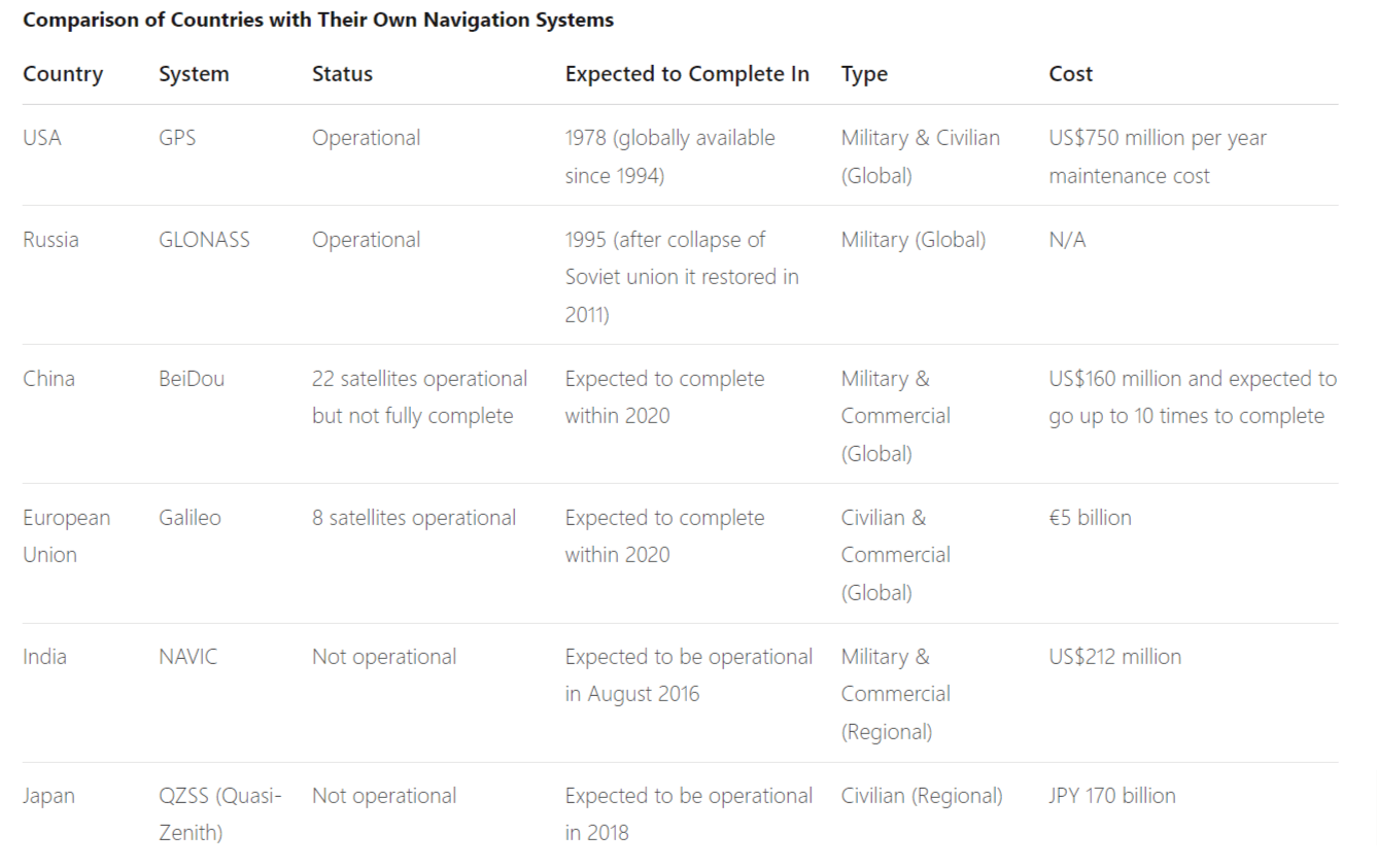
Table for comparing Different Countries Navigation Systems
| Country | System | Status | Expected to Complete In | Type | Cost |
| USA | GPS | Operational | 1978 (globally available since 1994) | Military & Civilian (Global) | US\$750 million per year maintenance cost |
| Russia | GLONASS | Operational | 1995 (after collapse of Soviet union it restored in 2011) | Military (Global) | N/A |
| China | BeiDou | Not Operational | Expected to complete within 2020 | Military & Commercial (Global) | US\$160 million and expected to go up to 10 times to complete |
| European Union | Galileo | 8 satellites operational | Expected to complete within 2020 | Civilian & Commercial (Global) | €5 billion |
| India | NAVIC | Expected to be completed within 2020 | Expected to be operational in August 2016 | Military & Commercial (Regional) | US\$212 million |
| Japan | QZSS (Quasi-Zenith) | Not Operational | Expected to be operational in 2018 | Civilian (Regional) | JPY 170 billion |
France and Japan are in the process of developing regional navigation systems.
However, NAVIC is currently testing and will be operational in august, 2016. it is expected that NAVIC will work better than GPS and provide accurate information.
What do you think about NAVIC? comment..